Place
| Home | Browse | Search | Previous | Next |
|
|
Unlocking Regional Memory
Place
|
|
Guyra (c. 1835 - ) |
|||
|
|||
| Guyra, New South Wales, Australia |
|
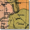
A town of northern New South Wales situated on the New England Highway, approximately 621 kilometres by rail from Sydney. Sitting on top of the Great Dividing Range, Guyra is renowned for its bracing climate and occasional snowfalls. A few kilometres east of Guyra is Chandlers Park, the highest peak of the New England range. The town takes its name from the local Aboriginal dialect. It is commonly accepted that guyra means fish may be caught, a reference to the Mother of Ducks Lagoon which is situated on the towns western fringe. European settlement of the area began around 1835, when Alexander Campbell set out to discover unexplored land beyond the newly-settled areas around Gostwyck and Saumarez (near present-day Armidale). Impressed by what he found, Campbell took up Guyra Station as an agent for Peter McIntyre of Maitland. The station took in the lands of the later township and immediate surrounds. By the 1860s, a small settlement had grown to service Guyra Station, which by this time had been split into two separate runs Guyra East and Guyra West. Situated to the east of the present town site, the settlement had a general store, a public house, a butcher shop and a blacksmith, all under the proprietorship of William Millis. But the township remained dormant until the 1880s, when Guyra became one of two stopovers on the northern rail link to Glen Innes. On 19 August 1884, Guyra Railway Station was opened, and in March the following year, Guyra was proclaimed a town. Economically the region had developed strongly along agricultural lines. Potatoes were grown in Guyra from the beginning, and became such an important staple of the local economy that the Guyra Argus in 1906 described it as the premier potato growing district in New South Wales. Other crops included wheat and oats. Cattle and especially sheep, which grazed on the large pastoral runs around the town, were also an important part of the local economy in the late-nineteenth century. With the arrival of the railway, Guyras primary industries developed more rapidly. No longer dependent on laboriously slow drays and carts, local farmers and graziers could now take advantage of the railway to secure a much faster and cheaper means of transporting their wool and produce to market. The immediate result of these developments was greater prosperity and new settlers. By the turn of the century, Guyra was home to a railway station, three hotels (the Guyra, Tattersalls and the Royal), a public school, Anglican and Roman Catholic churches, a police station, three general stores, a makeshift hospital (converted to a public hospital in 1956), and a saw-mill (Pearson and Sons). Later developments included a purpose-built post office, a potato factory (R Hall and Sons), a newspaper (the Guyra Argus, which remained in print until 1957), a public high school (established in 1970), and an abattoir (which has since been closed). Today Guyras farming and grazing communities remain the backbone of its wealth, a fact which is celebrated annually with the Guyra Show, Guyra Rodeo, and Lamb and Potato Festival. The Lamb and Potato Festival is held every year during the fourteen days prior to the Australia Day long weekend and attracts thousands of tourists from across the region and state. Stalls are erected on the main highway to promote Guyras established and burgeoning primary industries (trout and Alpaca farming are amongst the towns newest endeavours). | |
| |
| |
|
|
| ||
|
Published by The Australian Science and Technology Heritage Centre, 5 April 2004 Prepared by: Acknowledgements Updated: 23 February 2010 http://www.nswera.net.au/biogs/UNE0685b.htm |